
")
we have three aircraft, several aerial cameras
and laser scanners

The oldest and also the "most experienced" aircraft in our fleet, the Cessna 402B is used primarily for aerial photography with a Vexcel UltraCam Xp/Vexcel UltraCam Eagle Mark 3 camera, which is installed in a SOMAG GSM 3000/4000 gyro-stabilization mount. An IGI AEROcontrol-IIITM GPS/IMU unit is fitted in the aircraft. The Cessna is fitted with two holes in the floor and thus enables us to collect data simultaneously in real time using two sensors. The most commonly used combination is a large-format photogrammetric camera together with a laser scanner.

The Cessna 340A came to us later, and so is the newest member of our fleet. We use it primarily for aerial photography with a Vexcel UltraCam camera, which, as in the MIS, is installed in a SOMAG GSM 3000/4000 gyro-stabilization mount. This aircraft is fitted with an IGI AEROcontrol-IITM GPS/IMU unit.

We use our smallest aircraft, the Cessna 206F, mostly for carrying the aerial laser scanner and for smaller tasks, for example, thermal mapping. The Cessna is equipped with a Leica PAV80 gyro-stabilized sensor mount and Leica IPAS20 GPS/IMU system.

We have one of most advanced camera systems by Vexcel, namely the UltraCam Eagle Mark 3. One PAN image has a size of 26,460 x 17,004 px, which means a 450 Mpx image, and the physical size of one pixel is 4 microns. So, at a flight altitude of 2,500 m and a GSD of 10 cm, the real size of the area pictured in a single image is a considerable 2,646 meters transversely and 1,700 meters in the flight direction.
The camera is capable of taking images from up to five kilometres in altitude with 10 cm ground accuracy. It is able to save an image every second and a half and consists of four lenses through which it scans four colour channels – RBG and NIR. Thus, it is necessary to take less than half the images of any given location when compared with our older UltraCam Xp.

An older aerial camera system by Vexcel; we own two of them. One PAN image has a size of 17,310 x 11,310 px, the pixel size at a flight altitude of 500m is equivalent to 2.9 cm and the physical size of one pixel is 6 microns. The camera scans 4 colour channels – RGB and NIR, and can save one image every two seconds.

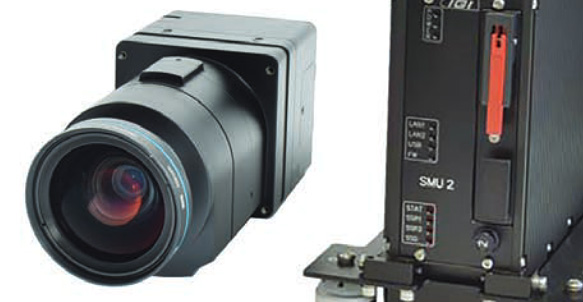
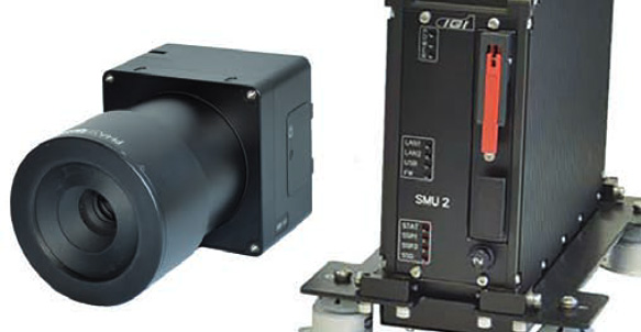
The IGI LiteMapper is designed as a robust but also very compact and lightweight system for aerial laser scanning that can be used in various types of aircraft, but also in ultralight aircraft or RPAS systems. All internal equipment is installed on vibration-damping platforms or in stabilization frames.
The scanner operates at a maximum flight altitude of up to 5,600 m, the standard flight level is 2,700 m. The position accuracy of the sensor equals 2 cm.
IGI DigiCAM 150 is a medium-format aerial camera with a resolution of 150 Mpx. It can save an image every 0.6 seconds and the size of one image is 14,204 x 10,652 px. The physical size of one pixel is 3.76 micrometres.
The advantage of this system consists in the possibility to use it together with a laser scanning system such as LiteMapper. Then the scanning width can be limited to the coverage of the aerial scanner.
Together with the IGI DigiCAM-100 and IGI DigiTHERM-640 it forms a part of so-called IGI Modular Aerial Camera Systems. All cameras in the system have similar components, which means that the same frame is installed in the aircraft and thus the replacement of systems is considerably facilitated when installed in the aircraft. Another advantage lies in the variability of individual components and the possibility to use them as complementary elements to other products of this series (for example, the combination we use of LiteMapper with DigiCAM, or the combination of the DigiTHERM system with DigiCAM).
IGI DigiCAM 100 is a medium-format aerial camera with a resolution of 100 Mpx. It can save an image every 0.6 seconds and the size of one image is 11,608 x 8,708 px. The physical size of one pixel is 4.6 micrometres. We use it to take images in the NIR band.
The advantage of this system consists in the possibility to use it together with a laser scanning system such as LiteMapper. Then the scanning width can be limited to the coverage of the aerial scanner.
Together with the IGI DigiCAM-150 (RGB) and IGI DigiTHERM-640 it forms a part of so-called IGI Modular Aerial Camera Systems. All cameras in the system have similar components, which means that the same frame is installed in the aircraft and thus the replacement of systems is considerably facilitated when installed in the aircraft. Another advantage lies in the variability of individual components and the possibility to use them as complementary elements to other products of this series (for example, the combination we use of LiteMapper with DigiCAM, or the combination of the DigiTHERM system with DigiCAM).

IGI DigiTHERM 640 is a digital thermal camera with a resolution of 640 x 512 px. The camera operates in a temperature range from -40 to 120 degrees Celsius with an accuracy of ±1°C or ±1%.
Together with the IGI DigiCAM-150 (RGB) and IGI DigiCAM-100 (NIR) it forms a part of so-called IGI Modular Aerial Camera Systems. All cameras in the system have similar components, which means that the same frame is installed in the aircraft and thus the replacement of systems is considerably facilitated when installed in the aircraft. Another advantage lies in the variability of individual components and the possibility to use them as complementary elements to other products of this series (for example, the combination we use of LiteMapper with DigiCAM, or the combination of the DigiTHERM system with DigiCAM).

Our three Vexcel UltraScan 5000 photogrammetric scanners scan thousands of archival aerial photographs every year. They can scan negatives, slides and contact paper copies of aerial photographs, either individually cut or from rolls, up to 30 x 30 cm format.